About PPGpS Lite
Flight Computer for Paramotor, Paraglider, Glider and Ultra Light plane Pilots Welcome to PPGpS, a Flight Computer for Paramotor, Paraglider, Glider and Ultra Light plane Pilots *WARNING there are missing features in the...
Flight Computer for Paramotor, Paraglider, Glider and Ultra Light plane Pilots
Welcome to PPGpS, a Flight Computer for Paramotor, Paraglider, Glider and Ultra Light plane Pilots
*WARNING there are missing features in the Lite version:
-Log flights in KML/IGC format
-Waypoints management
-Airspace display
-QNH/QFE altimeter setting
-Android Wear smartwatches via PPGpS Wear compatibility
-The annoying popups are removed in the Full version
-Display instruments on your Android Wear SmartWatch
*FEATURES OVERVIEW:
-Real time flight information
-Wind direction and speed estimation
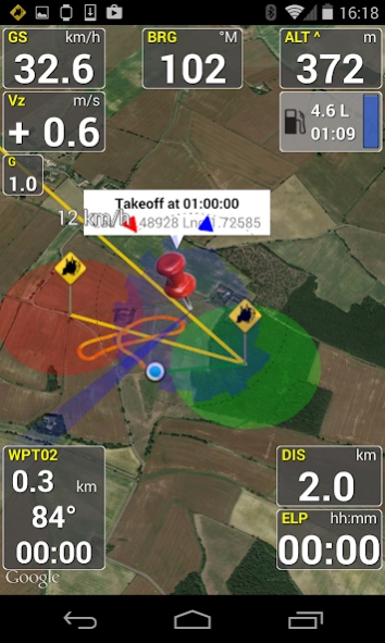
-Takeoff and Landing phases auto-detection
-Return home information (display estimated travel time and bearing)
-Fuel calculation and warning
-Airspace display (OpenAir files)
-Emergency geo-localized SMS
-Localization with GPS
-Barometric sensor support to improve altitude accuracy
-QHN, QFE Altimeter setting
-Online and offline maps
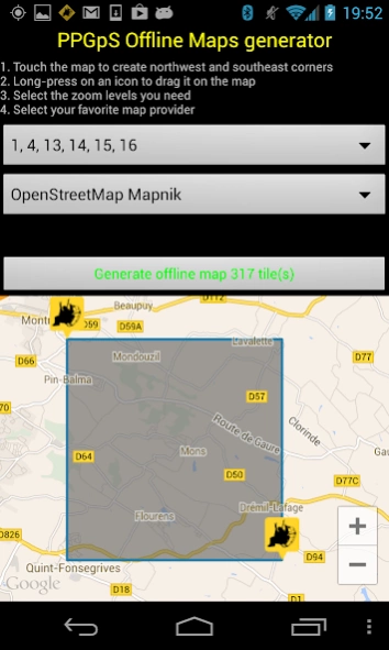
-Offline maps creator
-Google Maps and OpenStreetMap map providers
-Rotating Map
-Log flights in KML (for Google Earth), IGC (Leonardo servers) and GPX files
-Replay recorded flights
-Waypoint management
-Especially developed for Paramotor
-Embedded User Manual and Tip of the day feature.
-Real time flight tracking on www.ppgps.info
-Variometer
-Sunset time
-FlyNet2, Flight Bandit, BlueFlyVario variometer support
-Android Wear SmartWatch support with PPGpS Wear
*MAPS:
Online:
PPGpS can display Google or OpenStreetMap maps in connected mode.
Offline:
Download map files in your smartphone in case you don't have an internet connection during the flight.
Use the integrated PPGpS Offline Map Creator to generate offline maps.
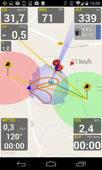
*INSTRUMENTS:
PPGpS provides the altitude, vario, bearing, magnetic compass, acceleration and ground speed.
With just one click on instruments you switch easily between different data modes : instantaneous, average and maximum values.
Altimeter can be set to actual altitude or elevation (QHN, QFE) just by long-pressing on the altimeter.
If your smartphone has a barometric sensor, it could be used to compute a very accurate altitude.
You can use PPGpS Wear companion application to display your instruments on your SmartWatch.
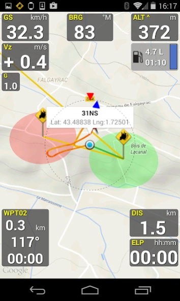
*WAYPOINTS:
Create waypoints by tapping on the map or by entering their GPS coordinates.
Select a waypoint with one click on the waypoint instrument (WPT).
Rename or remove a waypoint from the contextual menu of the waypoint list.
Follow the displayed route (bearing, estimated travel time and distance).
Prepare your waypoints from Google Earth and import your KML files (PPGpS folder in the phone).
Waypoints may be automatically loaded at startup and saved at the end of the session.
In case your KML file doesn't import well, please send me the file and I will fix it quickly.
*WIND AND SPEEDS HUD:
The average ground speeds are graphically displayed for every azimuth.
The wind direction is displayed (red arrow) and may be reset at any time during the flight.
*RETURN HOME:
Home direction and Estimated Travel Time to return home is always displayed (shaded red line).
Computations are done according to the wind for accurate results.
*LIVE TRACKING:
Enable the Live Tracking feature to allow your friends and family to see you live on map ! Go to www.ppgps.info for more details.
*AIRSPACE:
Copy OpenAir files in the /ppgps/airspace folder to display airspaces on top of the map
Use my other app AirspaceMap to help you download and customize your openAir files
https://play.google.com/store/apps/details?id=com.ns31.airspacemap
Launch the Demonstration mode to have a quick tour.
Visit http://www.ppgps.info
Find us on Facebook : https://www.facebook.com/ppgps
and Twitter : https://twitter.com/PPGpSAndroid
Enjoy your flights with PPGpS and thank you for your feedback.
Don't hesitate to send me your kml flight logs by mail :
[email protected]
Previous Versions
Here you can find the changelog of PPGpS Lite since it was posted on our website on 2014-06-13 02:26:28.
The latest version is 1.59a and it was updated on 2024-04-23 10:02:59. See below the changes in each version.
PPGpS Lite version 1.59a
Updated At: 2021-05-26
Changes: 1.59a 05/2021
Support generic LK8Ex1 protocol for bluetooth altivarios
Timestamps in KML track files for better replay
Bug fix on Replay
Bug fix on Tip of the day
1.58 04/2021
Italian translation completed
Airspace file parsing improved
File security issue with Android 11 fixed
1.57 04/2021
Input Map and Waypoint name fixed
Elevation above ground crash fix
1.56 09/2020
Floating text color configurable
Lock the screen in portrait, landscape and inverted
PPGpS Lite version 1.59
Updated At: 2021-05-16
Changes: 1.59 05/2021
Support generic LK8Ex1 protocol for bluetooth altivarios
Timestamps in KML track files for better replay
Bug fix on Replay
Bug fix on Tip of the day
1.58 04/2021
Italian translation completed
Airspace file parsing improved
File security issue with Android 11 fixed
1.57 04/2021
Input Map and Waypoint name fixed
Elevation above ground crash fix
1.56 09/2020
Floating text color configurable
Lock the screen in portrait, landscape and inverted
PPGpS Lite version 1.58
Updated At: 2021-04-23
Changes: 1.58 04/2021
Italian translation completed
Airspace file parsing improved
File security issue with Android 11 fixed
1.57 04/2021
Input Map and Waypoint name fixed
Elevation above ground crash fix
1.56 09/2020
Floating text color configurable
Elevation above ground (experimental feature)
Lock the screen in portrait, landscape and inverted
1.55 09/2020
Configurable cockpit layout fixed
Android 10 compatibility fixes
Large text settings issue fixed
Set QHN and QFE in hPa
PPGpS Lite version 1.56
Updated At: 2020-09-20
Changes: 1.56 09/2020
Floating text color configurable
Elevation above ground (experimental feature)
Lock the screen in portrait, landscape and inverted
1.55 09/2020
Configurable cockpit layout fixed
OpenStreetMap provider fixed
OpenTopoMap provider added
Android 10 compatibility fixes
Large text settings issue fixed
Set QHN and QFE in hPa
Compatibility with BluflyVario latest firmware
Use bluetooth variometers for altitude
Unified selection for altimeter and variometer providers
PPGpS Lite version 1.55
Updated At: 2020-09-07
Changes: 1.55 09/2020
Configurable cockpit layout fixed
OpenStreetMap provider fixed
OpenTopoMap provider added
Android 10 compatibility fixes
Large text settings issue fixed
Lock the screen in portrait or landscape
Set QHN and QFE in hPa
Compatibility with BluflyVario latest firmware
Use bluetooth variometers for altitude
Unified selection for altimeter and variometer providers
Added a close button on the "Tip of the day" window
PPGpS Lite version 1.54
Updated At: 2020-09-04
Changes: 1.54 09/2020
Android 10 compatibility fixes
Large text settings issue fixed
1.53 08/2020
Configurable cockpit layout
Lock the screen in portrait or landscape
Set QHN and QFE in hPa
Compatibility with BluflyVario latest firmware
Use bluetooth variometers for altitude
Unified selection for altimeter and variometer providers
Added a close button on the "Tip of the day" window
Added a Close button on the popup screen in the Lite version
Graphical enhancement
AndroidX migration
PPGpS Lite version 1.52
Updated At: 2019-02-10
Changes: 1.52 01/2019
Removed unecessary permissions for Google compliance
Menu to display Complex Hulls in recorded tracks screen
New settings for engine, wing and aircraft type
1.5 11/2018
Flight details screen improved
BlueFlyVario support
IGC files improvements
Min/Max vario displayed and logged
Pilot's name configurable for logs
Remove some not required permissions
Feet per second unit available for vario
PPGpS Lite version 1.46
Updated At: 2017-07-21
Changes: 1.46 07/2017
Bug fix: decimal point for Longitude
1.45 06/2017
Polish translation
1.43, 1.44 11/2016
Airspace files rename function
Flight logs list sorted (recent flights first)
Offline maps and airspace maps lists sorted
User manual in italian
1.42 11/2016
GPS disconnection fixed
PPGpS Lite version 1.40
Updated At: 2016-06-12
Changes: 1.40 06/2016,Bug fix in Waypoint import when altitude is not set,Bug fix in the Maximum Altitude report when the altitude has been manually setted,Italian translation updates,Italian user manual
PPGpS Lite version 1.25
Updated At: 2013-06-18
Changes: Several fixes and updates